Sail Gharbh Far West Top photos
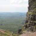
The ridge to Sàil Ghorm

and licensed for reuse under this Creative Commons Licence


Hover over the map markers to see associated photo. Note, some markers show photographer's position whilst others show photo subject location.
['The ridge to Sàil Ghorm',58.2145,-5.06818,'/public/geophotos/2478762.jpg'],['Approaching Quinag\'s north summit ridge',58.2145,-5.06852,'/public/geophotos/1816679.jpg'],['North ridge of Quinag',58.2143,-5.06817,'/public/geophotos/1816685.jpg'],['View west from Quinag',58.2135,-5.06691,'/public/geophotos/956670.jpg']