Brea Hill photos
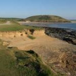
Brea Hill and Trebetherick across The Camel Estuary from Padstow

and licensed for reuse under this Creative Commons Licence


Hover over the map markers to see associated photo. Note, some markers show photographer's position whilst others show photo subject location.
['Brea Hill and Trebetherick across The Camel Estuary from Padstow',50.5571,-4.9259,'/public/geophotos/2775360.jpg'],['Brae Hill from mid-river, Camel estuary',50.5572,-4.92605,'/public/geophotos/1473251.jpg'],['Daymer Bay and Brea Hill',50.5597,-4.92677,'/public/geophotos/1532130.jpg'],['Coast at Daymer Bay',50.5633,-4.93024,'/public/geophotos/2391905.jpg'],['Brea Hill, Trebetherick',50.5568,-4.92659,'/public/geophotos/29595.jpg']