Carlton Moor photos
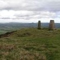
Carlton moor.

and licensed for reuse under this Creative Commons Licence


Hover over the map markers to see associated photo. Note, some markers show photographer's position whilst others show photo subject location.
['Carlton moor.',54.4159,-1.20099,'/public/geophotos/2202832.jpg'],['Carlton Moor Trig pillar',54.416,-1.20161,'/public/geophotos/2836165.jpg'],['View From the Summit of Carlton Moor',54.4159,-1.20099,'/public/geophotos/412328.jpg'],['Carlton Moor summit',54.4158,-1.20099,'/public/geophotos/276853.jpg'],['Trig point and boundary marker on Carlton Moor',54.4158,-1.20161,'/public/geophotos/2095460.jpg'],['Descending Carlton Bank',54.4164,-1.2016,'/public/geophotos/938358.jpg'],['View from Carlton Moor',54.4164,-1.20052,'/public/geophotos/2959445.jpg'],['Final Climb up Carlton Bank',54.4159,-1.20238,'/public/geophotos/776005.jpg'],['Descent from Carlton Moor',54.4167,-1.19897,'/public/geophotos/582747.jpg'],['Looking Down on the Lords\' Stone Country Park',54.4168,-1.19897,'/public/geophotos/1158712.jpg']