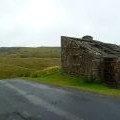
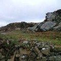
High Greygrits photos
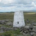
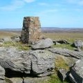
Ordnance Survey Trig Pillar 10415

and licensed for reuse under this Creative Commons Licence

Hover over the map markers to see associated photo. Note, some markers show photographer's position whilst others show photo subject location.
['Ordnance Survey Trig Pillar 10415',54.475,-2.19155,'/public/geophotos/2978969.jpg'],['O.S, Trig Point on High Greygrits',54.4749,-2.19178,'/public/geophotos/608783.jpg'],['High Greygrits trig point, 522m',54.4749,-2.19178,'/public/geophotos/1346131.jpg'],['High Greygrits',54.4753,-2.1924,'/public/geophotos/2018174.jpg'],['Quarry',54.4758,-2.19255,'/public/geophotos/608825.jpg'],['High Greygrits',54.4744,-2.19286,'/public/geophotos/1579169.jpg']