Whernside photos
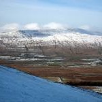
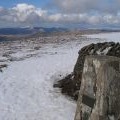
Whernside viewed from Park Fell

and licensed for reuse under this Creative Commons Licence


Hover over the map markers to see associated photo. Note, some markers show photographer's position whilst others show photo subject location.
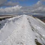
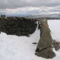
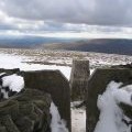
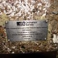
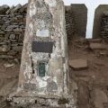
['Whernside viewed from Park Fell',54.2265,-2.40306,'/public/geophotos/2797411.jpg'],['Whernside summit',54.2277,-2.40262,'/public/geophotos/5993851.jpg'],['Whernside summit ridge',54.2284,-2.40231,'/public/geophotos/747197.jpg'],['Whernside viewed from Batty Green',54.2287,-2.40171,'/public/geophotos/5724002.jpg'],['Whernside',54.2276,-2.40338,'/public/geophotos/708232.jpg'],['Shelter and trig point on Whernside',54.2277,-2.40262,'/public/geophotos/745504.jpg'],['Whernside trig point and stile in the snow',54.2277,-2.40262,'/public/geophotos/745509.jpg'],['Whernside shelter, trig point, and pond',54.2277,-2.40262,'/public/geophotos/745535.jpg'],['Whernside Millennium Viewpoint plaque',54.2277,-2.40262,'/public/geophotos/745543.jpg'],['Whernside summit stile and trig point in the snow',54.2277,-2.40262,'/public/geophotos/746235.jpg'],['View to the Howgills from Whernside summit.',54.2277,-2.40262,'/public/geophotos/746241.jpg'],['Footpath to Whernside summit',54.2277,-2.40262,'/public/geophotos/747412.jpg'],['Footpath on lower slopes of Ingleborough Hill',54.2278,-2.40265,'/public/geophotos/432705.jpg'],['Whernside Trig Point',54.2278,-2.40263,'/public/geophotos/253929.jpg'],['Whernside trig point and stile',54.2278,-2.4026,'/public/geophotos/1886858.jpg']