Mendick Hill photos
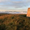
Mendick Hill trig

and licensed for reuse under this Creative Commons Licence


Hover over the map markers to see associated photo. Note, some markers show photographer's position whilst others show photo subject location.
['Mendick Hill trig',55.7402,-3.40078,'/public/geophotos/1073895.jpg'],['Mendick Hill',55.7402,-3.40078,'/public/geophotos/2568835.jpg'],['Triangulation Point on Mendick Hill',55.7402,-3.40062,'/public/geophotos/1962948.jpg'],['Mendick Hill',55.7402,-3.40047,'/public/geophotos/683178.jpg'],['Mendick Hill',55.7404,-3.40095,'/public/geophotos/1356584.jpg'],['Packing up',55.7407,-3.40128,'/public/geophotos/1962961.jpg'],['Summit, Mendick Hill.',55.7399,-3.40157,'/public/geophotos/83371.jpg'],['Cottongrass or Mountain Silk',55.7403,-3.39967,'/public/geophotos/1962955.jpg'],['Mendick Hill',55.7392,-3.4025,'/public/geophotos/1744036.jpg']