Mynydd Mawr photos
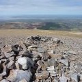
Mynydd Mawr Summit Cairn

and licensed for reuse under this Creative Commons Licence

Hover over the map markers to see associated photo. Note, some markers show photographer's position whilst others show photo subject location.
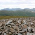
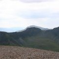
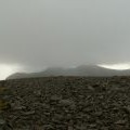
['Mynydd Mawr Summit Cairn',53.0696,-4.1811,'/public/geophotos/822711.jpg'],['Nantlle Ridge from Mynydd Mawr Summit',53.0696,-4.1811,'/public/geophotos/823152.jpg'],['Summit Plateau, Mynydd Mawr',53.0693,-4.1807,'/public/geophotos/1833472.jpg'],['Anglesey from Mynydd Mawr Summit',53.0695,-4.18205,'/public/geophotos/1833481.jpg'],['The Nantlle Ridge Range from Mynydd Mawr Summit.',53.0693,-4.1798,'/public/geophotos/614790.jpg']