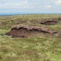
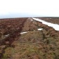
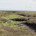
Stangend Rigg photos
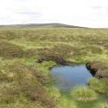
Boggy area on Stangend Rigg - close-up

and licensed for reuse under this Creative Commons Licence

Hover over the map markers to see associated photo. Note, some markers show photographer's position whilst others show photo subject location.
['Boggy area on Stangend Rigg - close-up',54.7879,-2.24815,'/public/geophotos/3023420.jpg'],['Peat haggs on Stangend Rigg (3)',54.7886,-2.24847,'/public/geophotos/3023416.jpg'],['Peat haggs on Stangend Rigg (2)',54.7884,-2.248,'/public/geophotos/3023412.jpg'],['Stangend Rigg',54.7879,-2.24753,'/public/geophotos/1758149.jpg'],['Peat haggs on Stangend Rigg',54.7886,-2.24784,'/public/geophotos/3016104.jpg'],['Spongy ground on Stangend Rigg',54.7885,-2.25002,'/public/geophotos/3016097.jpg'],['Stangend Rigg (3)',54.7886,-2.25002,'/public/geophotos/3016092.jpg'],['Stangend Rigg (2)',54.7888,-2.25002,'/public/geophotos/3016081.jpg'],['The Northumberland/Durham county border ridge on Stangend Rigg',54.7892,-2.25049,'/public/geophotos/3016179.jpg'],['Stangend Rigg',54.789,-2.2508,'/public/geophotos/3016173.jpg']