Braeriach photos
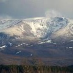
Braeriach from Aviemore

and licensed for reuse under this Creative Commons Licence


Hover over the map markers to see associated photo. Note, some markers show photographer's position whilst others show photo subject location.
['Braeriach from Aviemore',57.0782,-3.7285,'/public/geophotos/5351266.jpg'],['Braeriach (Braigh Riabhach)',57.0784,-3.72835,'/public/geophotos/3180669.jpg'],['Black Pinnacle',57.0779,-3.72634,'/public/geophotos/789122.jpg'],['Cairn Toul and West Buttress, Braeriach',57.0737,-3.724,'/public/geophotos/4587966.jpg'],['Summit Cairn, Braeriach',57.078,-3.72816,'/public/geophotos/2039119.jpg'],['Cairn Toul from Braeriach',57.0775,-3.72896,'/public/geophotos/2494735.jpg'],['Braeriach : Munro No 3',57.0773,-3.72879,'/public/geophotos/24084.jpg'],['The Black Pinnacle, Braeriach',57.078,-3.72717,'/public/geophotos/2226934.jpg']